REV: 1 (2022.02.09) TH
TELCARE is our Software as a Service solution for both TECDIS and COASTAL E. With a subscription to TELCARE, you get access to all new software functions developed for TECDIS and COASTAL E.
In software versions 4.8.3.3, 4.8.3.4 and 4.8.3.5 we added great features such as TotalTide integration, Rendezvous, Drag ‘n’ drop editing of route lane and turn radius, Curved EBL, EMRI autopilot interface to Curved EBL, Speed To Go (STG) Calculator, Improved route monitoring, long heading line and GNSS jamming and spoofing via Orolia M-SecureSync. In version 4.8.3.6 we added support for Scandinavian Micro Systems Optical Bearing Device (OBD) to the list of TelCare features, with much more to come in version 4.8.3.7 and beyond.
TelCare subscription status
With the addition of TELCARE you need a way to see if TELCARE is active on your system, and when the current subscription period ends.
To see if TELCARE is activated, simply open the chart information panel by:
- Pressing F4 on the keyboard, or
- Clicking on the “?” button in the chart menu.
If a valid TELCARE subscription is active, ‘TELCARE’ will be shown at the end of the ‘TECDIS software’ information.
To see when the current subscription period ends, place the cursor over the ‘TECDIS Software’ label, and the expiry date is shown in the hint text. You may also review the license information in TECDIS Setup (Service Key required).
TELCARE is administrated with license codes – you get a new code for each subscription period, directly from Telko.
TotalTide integration
TotalTide requires that Adimirality Digital Products (ADP) is installed on the the system, with a valid subscription to TotalTide.
ADP requires Windows 7 or newer, so TECDIS models 2026TC, 2138AA and 2138DA are not supported.
You open the Tides window by either clicking on a tidal stream station in the chart, or by clicking on the Tide button in the info panel. If you hover over the tidal station, you will see information about it in the chart.
Tide graph
The graph view shows you a tidal prediction graph, that can display up to 7 days of tidal data. If a minimum tidal height is configured, this will be indicated in the graph with red highlights for unsafe values.
Heights
This table shows you the hourly tidal height predictions for the coming 7 days.
High water / Low water
This display of tides is the common format on paper. You see the ends of the tidal movement, and what time of the day that happens.
Levels
This panel gives you general information about the specific tidal station.
Safe
The most powerful tool is the Safe tide table, that helps you plan your voyage taking tidal windows into account. The table shows the available tidal windows, and all calculations are based on the specified minimum safe tide.
Tidal stream stations
Tidal Stream stations work similarly to the Tidal stations but use a different symbol in the chart.
Tidal Stream stations have similar functionality as the Tidal stations. The main difference is that rates and directions are displayed.
Single click chart loading for GNS
With charts from GNS (Global Navigation Solutions) and their Voyager solutions for chart delivery, you now benefit from the single click chart loading solution in the system.
Updating your charts is now as simple as updating the Voyager drive with the latest charts, placing it in the system, and start the chart loading when the following window automatically appears:
When starting chart loading manually, both cell permits, and chart updates are now loaded in the same process.
Rendezvous - Predictive vessel approach
This feature is a user request that we are thrilled to add to the system.
For any target, you can now activate Rendezvous – RDV, and the system will predict where on your route will meet that target. This function works for targets within
1 NM of your route, and predicts where the target will meet your vessel (assuming the target will move along the same path your route shows).
Rendezvous supports up to 8 targets simulatneously, and the prediction is updated every second.
The tool is simple to use:
- When the system predicts that you will meet a target along your route, a Rendezvous-symbol is shown over the route.
- The symbol indicates if the point is a meeting or an overtaking.
- If you hold the cursor over the symbol, TTG (Time To Go) for the meeting and target name is shown.
- If you click on the symbol, you can pick it up to slide it along your route to find the Speed To Go to alter the rendezvous point to that position. All other rendezvous symbols will move accordingly. Click again to release the symbol.
- The symbol is shown in a target specific colour to help you recognize what target you will meet and where. The symbol colour is matched with brackets around the target.
Transit conning
The mini conning has always been very useful for maneuvers and while anchored. Now we have improved on it, with the addition of a transit conning.
So now the most important sensor and voyage information is displayed with bigger text, in a clear and very readable conning window.
You can move the window around by dragging it with your cursor.
To access the Transit conning you simply click anywhere on the docking conning.
Curved EBL
This new feature is a real gem. Curved EBL is a visual indication in the chart display of potential turn to be executed according to a specific turn radius and new course (taking wheel over distance into account), assuming the turn is initiated at the time of display.
Curved EBL is accessible via a new checkbox in the Ship menu. When checked, a new Curved EBL panel is shown in the top right corner of the chart display.
The Curved EBL panel consists of a clickable title with 3 possible modes (left click on title changes between modes):
- Curved EBL – Off: Not displayed in the chart.
- Curved EBL – Manual: Displayed according to parameters set in the system.
- Curved EBL – AP: Displayed according to turn radius and new course received from autopilot. Length and wheel over is still adjustable in the system.
This option is only available when information from the autopilot is received via track control or via the Options 3 sensor
(only selected autopilots (EMRI / Furuno FAP, Raytheon Anschutz NP5500).
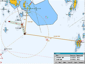
Curved EBL is displayed in the chart as a thick blue line starting at the conning position, extending straight for the wheel over distance, then turning according to the specified turn radius onto the specified new course and extending on this course until the total line length is of the specified distance.
If the specified distance is shorter than needed to complete the projected turn, the length is extended to the point of the projected turn.
- When using Curved EBL while in route monitoring, the curved EBL will assume that turns are triggered at the wheel over line.
- When the vessel passes the wheel over line, the curved EBL assumes that the turn is triggered at that point and starts counting down the curved EBL presented wheel over distance until it is 0.
- If the vessel starts turning before that point, the curved EBL presented wheel over distance is set to 0 at once.
Speed To Go (STG) calculator
The new Speed To Go (STG) Calculator is a feature available from the ETA calculator.
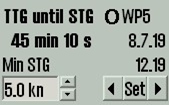
By clicking in the ETA calculator panel, the panel switches to an STG calculator mode. In this mode, you can set date and time for each waypoint (or own ship position) you have selected. When times are set for both waypoints, the required STG can be calculated and displayed.
When the STG calculator is shown, the ETA times are initialized with the current ETAs for the waypoints according to the current ETA mode (current / planned speed). If own ship position or waypoints behind the vessel are selected, the ETA time should be initialized to the current time.
If one of the selected endpoints is own ship, and the time specified is within 1 minute of the current time, that time should be updated according to current time on a continual basis while the calculator is displayed.
TTG calculations in the STG calculator
This is a special feature in the STG calculator, that allows you to calculate how long the current SOG can be maintained before speed must change to STG set in calculator to reach the set ETA.
The function is accessible by left clicking in the STG calculator (when own ship is selected as starting point).
Use own ship as start or end point for ETA calculations
This is a simple and useful addition to the ETA calculator in the system. You can now use own ship as a start or end point for the ETA calculations.
By right clicking on your own ship and the waypoint you want to calculate to/from, the ETA calculator is shown. Right clicking your own ship again when already selected removes the ETA calculator.
Calculate default speed from ETD and ETA
Until now, it has been possible to specify a single date/time for a waypoint in the waypoint list, and all other times were updated according to route speed settings. However, ships typically have a fixed departure time and a fixed arrival time.
Adjusting your default speed to comply with those fixed departure and arrival times has worked, but it has also required multiple steps. We have simplified this functionality, and the following improvements is added to the system in this release:
So now, when you specify an ETD and ETA for any two waypoints along the route, a default speed for the route is calculated automatically. Of course, it accounts for stop times and fixed speeds on specific route legs, providing you with a ready to use default speed.
And note that you are not limited to the end points of the route; you can calculate the default speed between any of the waypoints in the route.
In order to set a new fixed time (shown in orange), remove an existing fixed time.
Scandinavian Micro Systems Optical Bearing Device (OBD) integration
When the system is interfaced with a Scandinavian Micro Systems Optical Bearing Device, the bearings provided by the device are shown and used in the system in several ways:
- Whenever the bearing device is operated, the bearing is shown in the system.
- When a bearing is ‘triggered’ on the bearing device, the bearing is added to the bearing list.
- When the Lines of Position feature is in use, ‘triggering’ bearings on the bearing device adds the bearing automatically in the Lines of Position interface.
Radar overlay
The system can be configured to show the RADAR Overlay, elaborated by Furuno FAR-2xx7, FAR-2xx8 and FAR-3000 series and a selection of additional models (contact Furuno for details). When RADAR overlay is enabled, it can be activated from the Main toolbar by clicking on this icon or the F7 key.
Access to the configuration and settings of RADAR overlay is provided in the following way:
- Press the Menu button.
- Select the Setup menu tab.
- Open the dropdown menu Chart Utilities.
- Select Radar overlay setup.
A new Radar overlay correction window along with a sliding controller appear on the screen.
COASTAL R
This is an Costal E feature only.
Coastal R requires a valid TimeZero Professional license for installation.
This feature provides integration of TimeZero with Coastal E.
In Coastal you will get a Chart – Radar button to switch between chart and radar view with a simple click. This is a welcoming feature for smaller vessels in the way that you only need one screen for both charts and radar.
This feature will work with most radars in the Furuno lineup, including the FAR and DRS series.